(1)
That the zone is here indicated does
not want to say that is allowed flying
there. It is necessary to consult before the
proximity to airports, touristic or environmental restrictions,
presence of Nature Reserves, and other,
and asking previously the entities or corresponding individuals for the
permissions.
(2) The
coordinates UTM are in meters,
approximate, and corresponding to zone 31N ED50.
Whenever possible, they are indicated coordinates of the point of
raising or landing;
other times the coordinates of the peak is indicated, taking into
account that the raising always
a little is usually under the peak.
(3)
The L/D ratio describes like the relationship
among the distance (in horizontal projection)
and the difference of altitude (F=distance/difference). It is necessary to take into account that
although the up-to-date wings have
coefficients of L/D among 8 and 9, for
flights with L/D upper to 5, the
flight can be complicated
if there are not alternative fields and we have wind against or we find
descendants.
(4) The
following ones describe type of zones:
H = Place of usual flight
C = From Time to Time celebrate contests
E = Zones used by schools of flight, or
for training
M = Mountain zones that often accès
require on foot
(5) General
map of the zone at scale 1:50000 of the Cartographic Institute of Catalonia
Very advisable to consult the web page of the ICC to
search zones for coordinates UTM
or for toponyms.
(6) Links in web sites
that provide detailed information of the zones
Amigos del viento AMV
(Malloles, i altres) http://amigosdelviento.ning.com/
Equip de vol lliure (Olesa, i altres) EVL http://equipdevollliure.ning.com/
Bertigent (Bertí i altres) bertigent
Sompasdingu SPD
Appa appa
Club Alioth
Club de parapent Cap de Creu (zona
Girona) cc
Club vol lliure Ager vla
Alaire Club alaire
Zones de vol, de Brauli Torres bt
Llista zones, de Michel Mura mm
Club Icarus Girona (ala delta) ig
Laboratori d'envol le
Segur que hem deixo més llocs interessants...!!!
3. COORDINATES
UTM 31 OF THE ZONES OF FLIGHT
It is useful to remember that the coordinates UTM indicates the distàcies
in meters that there are from the point of control, until the meridian
and the parallel of reference. Thus, for Catalonia (that the zone UTM 31 corresponds),
the coordinate "x" it is the distance from the place until a meridian
placed at 500 Km to the west of Figueres. This is like the
center of the zone UTM 31 it is the
meridian of 3º East (that passes very near Figueres),
and the arbitrary value of 500000 m is given to the meridian of 3º. The coordinate "y"
is simply the distance in meters until
the equator,
that in Catalonia is from the order of 4500 Km = 4500000 meters.
And also usefull to remember to use the coordinates UTM, the GPS (although it helps)
not being necessary, since the majority
of the topographic maps they indicate a grill of coordinates, or still
easier, searching them to the web page of the ICC.
3.1 ZONE COORDINATES AND PLACES OF FLIGHT
(UNOFFICIAL)
x=
y= NOM
351621 4580098 COLL DE L'ILLA
513724 4685371 SANT PERE DE RODES
508028 4693575 PUIG D'ESQUERS (PIC)
495168 4703031 PUIG NEULÓS
477780 4696938 ROC D'EN FRAUSSA
361730 4676500 ORGANYÀ COGULLÓ
361440 4675870 CAMP ORGANYÀ
365737 4674826 VOLORIU
317597 4700658 GOTARTA
385810 4613402 LES MALLOLES
400508 4606273 MONTGROS
331030 4567827 CASTILLEJOS
398662 4621960 COLLBAIX
402026 4660513 MORRAL SOBRESTADA (1ªMARIA)
400646 4659023 PLA ROSSINYOL (2ªMARIA)
402900 4662396 QUERALT (RAMPA)
402517 4660263 LA RODA
402907 4664125 FIGUERRASSA
399109 4667102 RASOS DE PEGUERA
392070 4658701 CINGLES TARAVIL
397441 4670627 ENSITJA
393159 4677133 PEDRAFORCA
395158 4682264 COMABONA
412366 4683864 PUIGLLANÇADA
398405 4704777 PUIGPEDRÓS
417830 4707900 FONT ROMEU
349561 4594656 BELLTALL
455183 4708966 CANIGÓ
475897 4678730 MARE DE DEU MONT
469427 4684584 BASSEGODA
461154 4687069 COMANEGRE
467222 4680687 SADERNES
449498 4664058 PUIGSACALM
454539 4681232 EL TALLÓ
474067 4657761 ROCACORBA
444070 4595564 TEIÀ (BALDIRI)
448916 4600689 ARGENTONA (EL PUJOLAR)
473959 4610578 PINEDA
269866 4502275 LA SÈNIA
313555 4657599 ÀGER COLL D'ARES
315079 4652814 CAMPING
337720 4651655 VILANOVA DE MEIÀ
310630 4638235 OS DE BALAGUER (POBLE)
365289 4717908 MONTEIXO
356443 4717319 ARRÒS DE CARDÓS
315375 4707829 TOSSAL DE L'ORRI
341905 4702523 LLESSUI
345235 4702652 SURP (SERRAT DE POSA)
324497 4570337 EL MONTSANT (CORNUDELLA POBLE)
441686 4661491 BELLMUNT
433748 4628479 CENTELLES
445971 4696335 COSTABONA
438663 4689573 TREGURÀ
435976 4687586 PUIG CERVERÍS
440540 4679737 OGASSA (POBLE)
434954 4681456 TAGA
430275 4691065 FONTALBA (COLLADA)
427450 4692796 PUIGMAL
303711 4602436 ALFÉS
466325 4645997 PUIG D'AFROU
468110 4652520 SANTA BRIGIDA
459781 4644419 SANT BENET (CIM)
381232 4668892 PORT DEL COMPTE
379488 4672425 TOSSAL D'ESTIVELLA
377656 4664719 CANALDA (POBLE)
316544 4731041 MONTCORBISON (PIC)
418314 4610626 LA MOLA
430473 4595297 PENDETS MONTCADA
453230 4625129 TURÓ DE L'HOME
432329 4616845 SANT FELIU DE CODINES
454631 4693909 TORRE DE MIR
478236 4705089 CERET (PONT)
307947 4722713 ANETO (PIC)
293971 4639849 CASTILLONROI (POBLE)
3.2 UTM COORDINATES
CATALAN LEAGUE CONTEST
(2006):
X=
y=
z= NOM
325792.07 4670583.03 468.90 ESTACIO
TREMP
405895.69 4693213.69 1080.4 ALP AERODROM
374314.25 4690983.63 693.80 SEU D'URGELL
355403.42 4615381.37 539.30 CERVERA
317681.72 4629541.81 255.40
BALAGUER
323901.99 4638132.06 286.30
CAMARASSA
316401.66 4638632.08 617.00 VILANOVA SAL
314141.56 4648132.37 825.80
FONTDEPOU
309711.36 4655762.60 855.10 TORRE MOROS
309391.34 4668952.99 547.00 PONT
MONTANYANA
321151.86 4672883.11 838.40 ST ADRIA CONCA
312631.48 4680223.33 636.30 MOLI D'ARENY
332152.35 4679133.29 516.40 POBLA SEGUR
322761.93 4663782.83 853.50 CASTELL MUR
336152.54 4651132.45 607.90 VILANOVA MEIA
322031.90 4652822.50 367.00 ESTACIO AGER
311711.44 4678733.28 620.00 AER AREN
342342.81 4669543.00 937.70 ABELLA CONCA
357353.49 4658042.65 532.90
PERAMOLA
361433.67 4675953.18 603.80 ORGANYA
314541.58 4641612.17 595.70 LES AVELLANES
330152.26 4666132.90 449.00
VILAMITJANA
380154.54 4622381.58 716.00 CALAF
325242.05 4654302.55 853.00
PEDRERA-TERRADETS
319981.81 4653642.53 572.00
L'AMETLLA
337592.60 4651542.46 988.00 COGULLO
335860.52 4652062.47 873.70 ERM DE MEIA
337572.60 4640172.12 310.00 ARTESA SEGRE
349473.14 4642072.17 358.00 PONTS
338872.65 4665252.87 678.00 ISONA
402645.55 4659872.69 700.00 BERGA
329402.24 4649442.40 1369.0 SANT MAMET
293790.63 4710434.25 902.00 CASTEJON SOS
322821.94 4655582.59 972.00 PLA D'ESCUMOL
264289.38 4658782.71 389.00
BARBASTRO
314981.59 4652692.50 620.00 CAMPING
311741.45 4653502.53 673.00 AGULLO
313661.53 4654942.57 823.00 T
313451.52 4657462.65 1560.0 COLL D'ARES
315001.59 4655642.59 1293.0
GRABIELO
315131.60 4656692.62 1628.0 SANT ALIS
399715.42 4664872.84 1953.3 ROC AURO ANT
399025.38 4671463.04 2213.4 PUIG VOLTOR VERTICE
395795.24 4671643.04 2268.2 GALLINA
PELADA
392975.11 4677293.22 2416.4 PIC SUP PEDRAFORCA
389504.95 4676723.20 1452.1 CAST GOSOL
383224.66 4682713.38 2527.3 TORRE CADI
385564.77 4673123.09 2258.7 CAP VERD (CIM)
384954.74 4668102.94 1259.6 ANT SERRAT JOU
392495.09 4667382.92 1412.9 ERM MONTCALB
402785.56 4664012.81 1453.2 ANT
FIGUERASSA
414976.11 4672233.06 1613.2 PRAT CIM PUIG LLUENT
386224.80 4661102.73 1390.5 ANT BUSA
392935.11 4658202.64 1339.7 CAP PLANS ANT
396865.29 4659302.67 1258.7 ERM POBLE CAPOLAT
394755.19 4652022.46 869.30 TORRE
MONTMAJOR
403345.58 4651982.45 624.50 EDIF CAMP FUTBOL
398475.36 4656412.59 806.40 REST CRU CARRETERAS
404395.63 4658302.64 635.60 ESGL GRAUGES
405395.68 4660642.71 628.10 CAMPING BERGA RECEP
403055.57 4662422.77 1101.8 SANTUARI
QUERALT
402585.55 4661302.73 805.10 SP POLIGON
397905.33 4661822.75 1536.3 PRAT OEST LLADRES
398915.38 4663812.81 1463.2 SP PUIG VENTOS
396075.24 4692733.68 1096.5 PRULLANS NUCLI URB
372314.17 4665802.88 1292.5 CASTELL
D'ODEN
379324.49 4667642.93 2174.9 PUIG MORRERES
402625.55 4659892.69 702.00
CANFOGUES
418646.28 4651372.43 731.30 1PRATS
LLUCANES
406755.73 4693733.71 1085.0 AERODROM ALP
416776.19 4664992.84 819.00 PRAT ENT BORREDA
402475.54 4660112.70 728.30
SOBRESTRADES
466828.48 4652042.45 212.40 AMER
419916.34 4651882.45 723.30 2PRATS
LLUCANES
398575.36 4665892.87 2013.4 RASOS
402805.56 4662302.76 1132.0 QUERALT
324497.01 4570337.05 540.00 MONTSANT
NATURA
329158.22 4566176.93 820.00 GRANGES
ARTIGA
330229.27 4564295.87 360.00 ESGL ALFORJA
335149.50 4566089.93 380.00 ESGL VILAPLA
334768.48 4568708.00 990.00 ESGL MUSSARA
337152.59 4568248.99 1010.0 ANT MUSARA
332681.38 4568120.99 980.00 PUNTA DEL SEC
324523.01 4570358.05 530.00 ESGL CORNUDE
326715.11 4569527.03 730.00 ESGL SIURANA
323126.95 4572194.11 740.00 ERM ST J CODOLAR
326454.10 4573750.15 660.00 MAS D'EN LLUC
319198.77 4570513.06 740.00 ESGL MORERA
316545.65 4568669.01 420.00
ESCALADEI-CENTRE
316516.65 4569695.04 480.00
CARTOIXA-TEULAT
314238.54 4569685.04 580.00 MAS FORCANS
312457.46 4565771.92 220.00 ESGL VILA BAIXA
310425.37 4564723.90 640.00 ANT FIGUERA
311242.41 4561985.81 200.00 ESGL LLOAR
322244.91 4576688.24 650.00 ESGL
ULLDEMOLINS
328952.21 4579927.33 1020.0 ANT VVA PRADES
331598.33 4575187.19 960.00 ESGL PRADES
340746.75 4572521.11 0.0000 CASTELL
MONTRAL
330943.30 4567247.96 810.00 MAS DE REI
323972.99 4571441.09 612.00
ARMENGOL
322331.91 4577317.26 600.00
ULLDEMOLINS
340909.76 4571970.10 0.0000 MONTRAL
331022.31 4567906.98 940.00
CASTILLEJOS
323896.98 4573202.14 1047.0 PLA GRAN
323309.96 4572909.13 1140.0
CORBATERA
322555.92 4572361.11 1040.0 MOLONER
360623.62 4678343.26 1629.2 EL COGULLO
357413.49 4677443.23 691.60 EL VILAR
355053.37 4677413.23 771.70 ERM CABO
364033.79 4675913.18 847.90 VOLORIU
363193.75 4672113.07 1152.4 ROCA NARIEDA
362783.73 4673723.12 597.60 ERM FIGOLS
362193.71 4671923.06 535.60 PONT DESPA
355713.40 4673483.11 1131.0
MONTANISELL
360633.64 4670543.02 580.30 COLL DE NARGO
348283.08 4670493.02 1130.9 BOIXOLS
366953.92 4674313.13 1309.1 ROCA ALTA
359763.58 4674463.14 1200.0 SANTA FE
361433.67 4675953.18 603.80 ORGANYA
362246.70 4675007.15 563.00 CAMP BOTAFOCS
361723.67 4676583.20 813.20 ORGANYA
298130.75 4705333.09 1630.0 ANT COLL FADAS
305638.09 4707728.16 1310.0 DENUY
312068.39 4707428.15 1000.0 GINASTE CASA
319430.72 4708187.17 1090.0
BARRUERA
323248.90 4709513.21 1460.0 TAULL
285819.19 4698679.90 690.00 CAMPO
297876.74 4711595.28 2000.0 CASA PIEDRAS
BLANCAS
302595.95 4704862.08 1500.0 LAS PAULES
307807.19 4703382.03 1000.0 NOALES
308096.21 4699891.93 1250.0 BONANSA
323441.91 4702504.00 2620.9 CAP VEDATS ERTA
307861.19 4707764.16 1498.2
CASTANESA
322571.87 4699413.91 1508.7 ERTA
327002.08 4694633.76 1620.0 PUI DE FAR
316021.57 4699083.90 1186.9 GOTARTA
318341.68 4697713.86 1087.2 MALPAS
330862.25 4700853.95 2614.2 TOSSAL ASTELL
315261.53 4707694.16 2281.0 TOSSAL ORRI
323661.92 4699073.89 1990.5 TOSSAL
COGOMAR
313140.44 4699636.92 860.80 GOL PONT 1
313671.46 4699733.92 824.00 GOL PONT 2
319085.71 4707943.16 1086.3
BARRUERA
346251.03 4695981.98 674.50 SORT
312466.41 4705811.10 999.00
VILALLER
317597.64 4700657.94 1645.6 GOTARTA
ENLAIRAMENT
336482.55 4647882.35 505.40 GARZOLA
336332.55 4650812.44 578.20 GOL VILANOVA
335972.53 4650842.44 592.20 CAMP ST JORDI
333332.41 4652592.49 1235.3 SORT VILANOVA
468858.51 4646559.20 153.01 GOL CELLERA
466360.92 4645837.21 823.55 PUIG D'AFROU
458309.68 4671285.85 475.56 VOLCA ST FRANCESC
449663.00 4664441.77 1470.6
PUIGSACALM
443047.60 4661388.40 779.61 STA MA BELLMUNT
461665.33 4652291.31 1095.4 SANTUARI FAR
441265.23 4676266.79 777.06 ST JOAN ABADESSES
440432.16 4679633.71 953.08 OGASSA
433132.82 4672494.05 689.02 RIPOLL
431485.17 4683980.01 926.98 RIBES FRESER
415403.64 4677603.00 859.04 POBLA LILLET
407522.07 4676349.46 725.02 GUARDIOLA
BERGADA
464311.70 4645857.99 1074.4 ST GREGORI
425700.73 4663541.60 862.56 ALPENS
386085.98 4679301.66 1423.7 JOSA DEL CADI
472126.35 4634666.59 140.78 STA COLOMA FARNERS
471998.02 4651811.57 585.79 ST ROC
465869.62 4659989.26 411.56 ST ANIOL FINESTRES
475784.83 4678599.24 1099.2 MARE DEU MONT
453701.39 4666584.74 522.35 EL MALLOL
451065.68 4670999.77 577.93
RIUDAURA
459616.02 4644198.07 1122.3 ST BENET
476386.15 4649062.06 490.30 ST GRAU
461834.00 4656286.60 362.23 PLANES
HOSTOLES
459352.52 4658828.85 476.84 ST FELIU PALLEROLS
458313.20 4656987.01 1029.4 SANTUARI
SALUT
452987.51 4661342.82 936.76 ERM FALGARS
452259.36 4663416.60 565.19
JOANETES
454519.56 4661342.78 489.15 HOSTALESTS
BAS
467681.99 4640005.81 788.99 STA BARBARA
474946.54 4672207.82 170.80 BESALU
469442.49 4645456.23 150.61 ANGLES
462730.55 4644064.24 347.32 OSOR
470828.65 4646477.99 283.54 ST JULIA LLOR
467936.06 4652342.32 463.53 STA BRIGIDA
474054.81 4657870.79 969.02
ROCACORBA
479689.36 4662743.58 176.00
BANYOLES
462114.02 4665695.43 690.00 VOLCA STA MARGARIDA
269866.56 4502275.09 373.00 LA SENIA
265164.35 4500675.05 541.09 ERT ROSSELL
275578.82 4498476.98 250.00 ST RAFAEL
277759.91 4512510.39 372.96 MAS BARBERANS
287920.37 4510205.31 85.138 STA BARBARA
285204.25 4506186.20 114.76 CRUILLA
GALERA
270234.57 4504779.17 490.12 GOL LA SENIA
282168.11 4519111.58 158.87 GOL
PARELLADES
363743.78 4621149.54 649.37 GOL ST RAMON
286612.31 4519865.60 54.738 GOL RAVAL CRIST
270269.57 4505948.20 774.57 SORT
PALLEROLS
And finally, all the former zones (blue) and beacons (green)
in a map in Autocad (.dwg)
and also in photo format (.png):
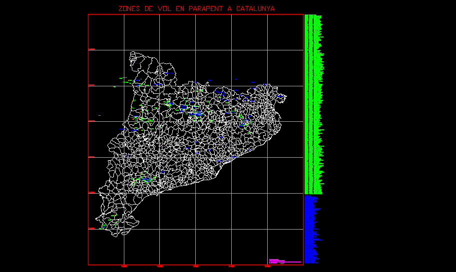
Zones of flight in format Autocad 2004
(type .dwg compressed in .zip format
Autocad 2004)

Zones of flight in photo format (type .png).
The photo has a resolution of 4800x6400 points and a computer needs a little
agile to scroll the image and to make zoom format
foto
Excuse this english language obtained with automatic machine translation by computer!!!